Showing posts with label nasa. Show all posts

Wednesday, March 14, 2012

NASA's Goddard, Glenn Centers Look to Lift Space Astronomy out of the Fog


A fogbank is the least useful location for a telescope, yet today's space observatories effectively operate inside one. That's because Venus, Earth and Mars orbit within a vast dust cloud produced by comets and occasional collisions among asteroids. After the sun, this so-called zodiacal cloud is the solar system's most luminous feature, and its light has interfered with infrared, optical and ultraviolet observations made by every astronomical space mission to date.
To put it simply, it has never been night for space astronomers," said Matthew Greenhouse, an astrophysicist at NASA's Goddard Space Flight Center in Greenbelt, Md. Light from zodiacal dust can be a thousand times brighter than the sources astronomers actually target, limiting sensitivity in much the same way that bright moonlight hampers ground-based observatories. The dust and its unwanted illumination are greatest in the plane of Earth's orbit, the same plane in which every space telescope operates.
Placing future astronomy missions on more tilted orbits would let spacecraft spend significant amounts of time above and below the thickest dust and thereby reduce its impact on observations. So Greenhouse teamed with Scott Benson at NASA's Glenn Research Center in Cleveland, Ohio, to investigate how these "dark sky" or extra-zodiacal orbits might improve mission science and to develop a means of cost-effectively reaching them.
"Just by placing a space telescope on these inclined orbits, we can improve its sensitivity by a factor of two in the near-ultraviolet and by 13 times in the infrared," Greenhouse explained. "That's a breakthrough in science capability with absolutely no increase in the size of the telescope's mirror."
Greenhouse, Benson and the COllaborative Modeling and Parametric Assessment of Space Systems (COMPASS) study team at NASA Glenn designed a mission that utilizes new developments in solar arrays, electric propulsion and lower-cost expendable launch vehicles. Their proof-of-concept mission is the Extra-Zodiacal Explorer (EZE), a 1,500-pound EX-class observatory that could accommodate a telescope in the size range of the recently completed WISE mission -- all within the cost and schedule constraints of NASA's Explorer Program.
Launched on a SpaceX Falcon 9 rocket, EZE would use a powerful new solar-electric drive as an upper stage to direct the spacecraft on a gravity-assist maneuver past Earth or Mars. This flyby would redirect the mission into an orbit inclined by as much as 30 degrees to Earth's.
The result, the scientists say, will be the highest-performance observatory ever achieved in the decades-long history of NASA's Explorer program.
"We see EZE as a game-changer, the first step on a new path for NASA Explorers that will yield major science goals despite limited resources," said Benson, who previously managed the new electric propulsion technology project.
Named NASA's Evolutionary Xenon Thruster (NEXT), the engine is an improved type of ion drive. Using electric power supplied by solar panels, the NEXT engines operate by removing electrons from atoms of xenon gas, then accelerating the charged ions through an electric field to create thrust. While these types of engine provide much less thrust at any given time than traditional chemical rockets, they are much more fuel efficient and can operate for years.
Built by Aerojet, an aerospace company based in Sacramento, Calif., each 6.9-kilowatt NEXT engine delivers two and a half times the thrust of the NSTAR ion engines now flying on NASA's Dawn spacecraft.
"We've run one NEXT thruster for over 40,000 hours in ground testing, more than twice the thruster operating lifetime needed to deliver the EZE spacecraft to its extra-zodiacal orbit," Benson explained. "This is mature technology that will enable much more cost-effective space missions across both the astrophysics and planetary science disciplines."
"Development of this solar-electric upper stage for Falcon 9, which the Goddard/Glenn EZE team is advocating, will make extra-zodiacal orbits available to any astronomer proposing to NASA's Explorer program. This will enable unprecedented science capability for astrophysics Explorers," Greenhouse said.
The EZE upper stage would carry two NEXT engines, their xenon gas propellant and two 18-foot-wide UltraFlex solar arrays built by Alliant Techsystems in Goleta, Calif. These arrays, which were originally developed for NASA's Orion Crew Exploration Vehicle, would see their first deep-space application with EZE. Once the spacecraft achieves the desired orbit, the transfer stage would separate and the science mission would begin.
The Goddard/Glenn study also showed that the EZE mission concept could be the lowest-cost option for a planned flight demonstration of a high-power solar-electric propulsion stage. A standardized solar-electric upper stage for the Falcon 9 that can be used by any mission will set the small-payload Explorer program on a new path to achieve science goals that rival the capability of larger, more expensive systems.
"Undertaking a project like this will provide key flight experience toward developing the higher-power systems needed to enable NASA's human exploration objectives in deep space while providing immediate scientific return on the investment," Greenhouse added.

Tuesday, February 28, 2012

The Many Moods of Titan


A set of recent papers, many of which draw on data from NASA's Cassini spacecraft, reveal new details in the emerging picture of how Saturn's moon Titan shifts with the seasons and even throughout the day. The papers, published in the journal Planetary and Space Science in a special issue titled "Titan through Time," show how this largest moon of Saturn is a cousin -- though a very peculiar cousin -- of Earth.

"As a whole, these papers give us some new pieces in the jigsaw puzzle that is Titan," said Conor Nixon, a Cassini team scientist at the NASA Goddard Space Flight Center, Greenbelt, Md., who co-edited the special issue with Ralph Lorenz, a Cassini team scientist based at the Johns Hopkins University Applied Physics Laboratory, Laurel, Md. "They show us in detail how Titan's atmosphere and surface behave like Earth's -- with clouds, rainfall, river valleys and lakes. They show us that the seasons change, too, on Titan, although in unexpected ways."
A paper led by Stephane Le Mouelic, a Cassini team associate at the French National Center for Scientific Research (CNRS) at the University of Nantes, highlights the kind of seasonal changes that occur at Titan with a set of the best looks yet at the vast north polar cloud.
A newly published selection of images -- made from data collected by Cassini's visual and infrared mapping spectrometer over five years -- shows how the cloud thinned out and retreated as winter turned to spring in the northern hemisphere.
Cassini first detected the cloud, which scientists think is composed of ethane, shortly after its arrival in the Saturn system in 2004. The first really good opportunity for the spectrometer to observe the half-lit north pole occurred on December 2006. At that time, the cloud appeared to cover the north pole completely down to about 55 degrees north latitude. But in the 2009 images, the cloud cover had so many gaps it unveiled to Cassini's view the hydrocarbon sea known as Kraken Mare and surrounding lakes.
"Snapshot by snapshot, these images give Cassini scientists concrete evidence that Titan's atmosphere changes with the seasons," said Le Mouelic. "We can't wait to see more of the surface, in particular in the northern land of lakes and seas."
In data gathered by Cassini's composite infrared mapping spectrometer to analyze temperatures on Titan's surface, not only did scientists see seasonal change on Titan, but they also saw day-to-night surface temperature changes for the first time. The paper, led by Valeria Cottini, a Cassini associate based at Goddard, used data collected at a wavelength that penetrated through Titan's thick haze to see the moon's surface. Like Earth, the surface temperature of Titan, which is usually in the chilly mid-90 kelvins (around minus 288 degrees Fahrenheit), was significantly warmer in the late afternoon than around dawn.
"While the temperature difference -- 1.5 kelvins -- is smaller than what we're used to on Earth, the finding still shows that Titan's surface behaves in ways familiar to us earthlings," Cottini said. "We now see how the long Titan day (about 16 Earth days) reveals itself through the clouds."
A third paper by Dominic Fortes, an outside researcher based at University College London, England, addresses the long-standing mystery of the structure of Titan's interior and its relationship to the strikingly Earth-like range of geologic features seen on the surface. Fortes constructed an array of models of Titan's interior and compared these with newly acquired data from Cassini's radio science experiment.
The work shows the moon's interior is partly or possibly even fully differentiated. This means that the core is denser than outer parts of the moon, although less dense than expected. This may be because the core still contains a large amount of ice or because the rocks have reacted with water to form low-density minerals.
Earth and other terrestrial planets are fully differentiated and have a dense iron core. Fortes' model, however, rules out a metallic core inside Titan and agrees with Cassini magnetometer data that suggests a relatively cool and wet rocky interior. The new model also highlights the difficulty in explaining the presence of important gases in Titan's atmosphere, such as methane and argon-40, since they do not appear to be able to escape from the core.
The Cassini-Huygens mission is a cooperative project of NASA, the European Space Agency and the Italian Space Agency. NASA's Jet Propulsion Laboratory manages the mission for NASA's Science Mission Directorate, Washington, D.C. The visual and infrared mapping spectrometer team is based at the University of Arizona, Tucson. The composite infrared spectrometer team is based at NASA's Goddard Space Flight Center in Greenbelt, Md., where the instrument was built. The radio science subsystem has been jointly developed by NASA and the Italian Space Agency.

Sunday, February 12, 2012

NASA's Chandra Finds Milky Way's Black Hole Grazing on Asteroids

 The giant black hole at the center of the Milky Way may be vaporizing and devouring asteroids, which could explain the frequent flares observed, according to astronomers using data from NASA's Chandra X-ray Observatory.

For several years Chandra has detected X-ray flares about once a day from the supermassive black hole known as Sagittarius A*, or "Sgr A*" for short. The flares last a few hours with brightness ranging from a few times to nearly one hundred times that of the black hole's regular output. The flares also have been seen in infrared data from ESO's Very Large Telescope in Chile.

"People have had doubts about whether asteroids could form at all in the harsh environment near a supermassive black hole," said Kastytis Zubovas of the University of Leicester in the United Kingdom, and lead author of the report appearing in the Monthly Notices of the Royal Astronomical Society. "It's exciting because our study suggests that a huge number of them are needed to produce these flares."

Zubovas and his colleagues suggest there is a cloud around Sgr A* containing trillions of asteroids and comets, stripped from their parent stars. Asteroids passing within about 100 million miles of the black hole, roughly the distance between the Earth and the sun, would be torn into pieces by the tidal forces from the black hole.

These fragments then would be vaporized by friction as they pass through the hot, thin gas flowing onto Sgr A*, similar to a meteor heating up and glowing as it falls through Earth's atmosphere. A flare is produced and the remains of the asteroid are swallowed eventually by the black hole.

"An asteroid's orbit can change if it ventures too close to a star or planet near Sgr A*," said co-author Sergei Nayakshin, also of the University of Leicester. "If it's thrown toward the black hole, it's doomed."

The authors estimate that it would take asteroids larger than about six miles in radius to generate the flares observed by Chandra. Meanwhile, Sgr A* also may be consuming smaller asteroids, but these would be difficult to spot because the flares they generate would be fainter.

These results reasonably agree with models estimating of how many asteroids are likely to be in this region, assuming that the number around stars near Earth is similar to the number surrounding stars near the center of the Milky Way.

"As a reality check, we worked out that a few trillion asteroids should have been removed by the black hole over the 10-billion-year lifetime of the galaxy," said co-author Sera Markoff of the University of Amsterdam in the Netherlands. "Only a small fraction of the total would have been consumed, so the supply of asteroids would hardly be depleted."

Planets thrown into orbits too close to Sgr A* also should be disrupted by tidal forces, although this would happen much less frequently than the disruption of asteroids, because planets are not as common. Such a scenario may have been responsible for a previous X-ray brightening of Sgr A* by about a factor of a million about a century ago. While this event happened many decades before X-ray telescopes existed, Chandra and other X-ray missions have seen evidence of an X-ray "light echo" reflecting off nearby clouds, providing a measure of the brightness and timing of the flare.

"This would be a sudden end to the planet's life, a much more dramatic fate than the planets in our solar system ever will experience," Zubovas said.

Very long observations of Sgr A* will be made with Chandra later in 2012 that will give valuable new information about the frequency and brightness of flares and should help to test the model proposed here to explain them. This work could improve understanding about the formation of asteroids and planets in the harsh environment of Sgr A*.

NASA's Marshall Space Flight Center in Huntsville, Ala., manages the Chandra program for NASA's Science Mission Directorate in Washington. The Smithsonian Astrophysical Observatory controls Chandra's science and flight operations from Cambridge, Mass.

For Chandra images, multimedia and related materials, visit:


For an additional interactive image, podcast, and video on the finding, visit:

NASA Mission Takes Stock of Earth's Melting Land Ice


In the first comprehensive satellite study of its kind, a University of Colorado at Boulder-led team used NASA data to calculate how much Earth's melting land ice is adding to global sea level rise.

Using satellite measurements from the NASA/German Aerospace Center Gravity Recovery and Climate Experiment (GRACE), the researchers measured ice loss in all of Earth's land ice between 2003 and 2010, with particular emphasis on glaciers and ice caps outside of Greenland and Antarctica.

The total global ice mass lost from Greenland, Antarctica and Earth's glaciers and ice caps during the study period was about 4.3 trillion tons (1,000 cubic miles), adding about 0.5 inches (12 millimeters) to global sea level. That's enough ice to cover the United States 1.5 feet (0.5 meters) deep.

"Earth is losing a huge amount of ice to the ocean annually, and these new results will help us answer important questions in terms of both sea rise and how the planet's cold regions are responding to global change," said University of Colorado Boulder physics professor John Wahr, who helped lead the study. "The strength of GRACE is it sees all the mass in the system, even though its resolution is not high enough to allow us to determine separate contributions from each individual glacier."

About a quarter of the average annual ice loss came from glaciers and ice caps outside of Greenland and Antarctica (roughly 148 billion tons, or 39 cubic miles). Ice loss from Greenland and Antarctica and their peripheral ice caps and glaciers averaged 385 billion tons (100 cubic miles) a year. Results of the study will be published online Feb. 8 in the journal Nature.

Traditional estimates of Earth's ice caps and glaciers have been made using ground measurements from relatively few glaciers to infer what all the world's unmonitored glaciers were doing. Only a few hundred of the roughly 200,000 glaciers worldwide have been monitored for longer than a decade.

One unexpected study result from GRACE was the estimated ice loss from high Asian mountain ranges like the Himalaya, the Pamir and the Tien Shan was only about 4 billion tons of ice annually. Some previous ground-based estimates of ice loss in these high Asian mountains have ranged up to 50 billion tons annually.

"The GRACE results in this region really were a surprise," said Wahr, who also is a fellow at the University of Colorado-headquartered Cooperative Institute for Research in Environmental Sciences. "One possible explanation is that previous estimates were based on measurements taken primarily from some of the lower, more accessible glaciers in Asia and extrapolated to infer the behavior of higher glaciers. But unlike the lower glaciers, most of the high glaciers are located in very cold environments and require greater amounts of atmospheric warming before local temperatures rise enough to cause significant melting. This makes it difficult to use low-elevation, ground-based measurements to estimate results from the entire system."

"This study finds that the world's small glaciers and ice caps in places like Alaska, South America and the Himalayas contribute about .02 inches per year to sea level rise," said Tom Wagner, cryosphere program scientist at NASA Headquarters in Washington. "While this is lower than previous estimates, it confirms that ice is being lost from around the globe, with just a few areas in precarious balance. The results sharpen our view of land ice melting, which poses the biggest, most threatening factor in future sea level rise."

The twin GRACE satellites track changes in Earth's gravity field by noting minute changes in gravitational pull caused by regional variations in Earth's mass, which for periods of months to years is typically because of movements of water on Earth's surface. It does this by measuring changes in the distance between its two identical spacecraft to one-hundredth the width of a human hair.

The GRACE spacecraft, developed by NASA's Jet Propulsion Laboratory, Pasadena, Calif., and launched in 2002, are in the same orbit approximately 137 miles (220 kilometers) apart.

For more on GRACE, visit:


For more information about NASA and agency programs, visit:

NASA Seeks Game Changing Technology Payloads for Suborbital Research Flights

NASA is seeking proposals for small technology payloads that could fly on future NASA-sponsored suborbital flights. These future flights will travel to the edge of space and back, testing the innovative new technologies before they're sent to work in the harsh environment of space.

"NASA's Game Changing Development Program focuses on maturing advanced space technologies that may lead to entirely new approaches for the agency's future space missions while providing solutions to significant national needs and adding to our nation’s innovation economy," said Michael Gazarik, director of NASA's Space Technology Program at NASA Headquarters in Washington. "This solicitation offers an opportunity to develop potentially transformative technologies that take advantage of our Flight Opportunities Program platforms, which allow frequent and predictable commercial access to near-space, with easy recovery of intact payloads."

NASA's Game Changing Opportunities research announcement seeks proposals for payloads, vehicle enhancements and onboard facilities for payload integration that will help the agency advance technology development in the areas of exploration, space operations and other innovative technology areas relevant to NASA's missions. Sponsored by NASA's Space Technology Program, the agency expects proposals from entrepreneurs, scientists, technologists, instrument builders, research managers, and vehicle builders and operators.

"This call for proposals is a great opportunity to develop innovative technology development payloads for flight on commercial suborbital, reusable vehicles which have novel ideas and approaches have the potential to revolutionize future space missions," said Stephen Gaddis, Game Changing Development program manager at NASA's Langley Research Center in Hampton, Va.

Special emphasis will be given to proposals that address basic and applied research as well as development for advanced technologies and the development of test articles and techniques for evaluating the articles. Following development, selected payloads will be made available to NASA's Flight Opportunities Program for pairing with appropriate suborbital reusable launch service provider flights.

In August 2011, NASA selected seven U.S. companies that can provide flight services and platforms to test innovative technology payloads through the Flight Opportunities Program. Under this solicitation, the selected Flight Opportunities suborbital reusable launch vehicles could be modified to facilitate integration and payload engineering of future payloads in support of specific research needs.

Proposals will be accepted from U.S. or non-U.S. organizations including NASA centers and other government agencies, federally funded research and development centers, educational institutions, industry and nonprofit organizations.

NASA expects to make approximately 20 awards this summer, with the majority of awards ranging between approximately $50,000 and $125,000 each. Several awards may be made for up to $500,000 in the area of vehicle integration and payload engineering technology enhancements and onboard research facilities to improve platform capabilities.

The Game Changing Opportunities in Technology Development research announcement is available through the NASA Solicitation and Proposal Integrated Review and Evaluation System website at:


NASA's Langley Research Center manages the Game Changing Development Program and NASA's Dryden Flight Research Center at Edwards, Calif., manages the Flight Opportunities Program for the agency's Space Technology Program.

For more information on the Game Changing Development activities and information on this solicitation for payloads, visit:


For more information about NASA's Flight Opportunities Program, visit:

Station Astronauts Capture Stunning Views of U.S., Canada, Northern Lights

Astronauts aboard the International Space Station recently filmed what is among the most spectacular night imagery ever taken from space of the United States. The video, comprised of hundreds of sequential still images, will air on NASA Television's video file beginning today.

The imagery also is available on the internet at NASA's Gateway to Astronaut Photography of Earth:


Taken between Jan. 29-Feb. 3, the images show a continent ablaze with light, from the electric glow of hundreds of cities to a spectacular aurora borealis flickering on the northern horizon. The video includes flights above Mexico showing the entire Gulf Coast and continuing the length of the East Coast. Other video capture scenes from Brownsville, Texas, to the Great Lakes and above the St. Lawrence Seaway. Still another sequence begins in the western U.S. and continues across the Great Plains.

New imagery also shows the aurora during flights above Canada. The imagery was taken using a still camera aboard the station, orbiting 240 miles above Earth. For more about the International Space Station, visit:


For NASA Television schedules, downlink information and streaming video, visit:
 

Friday, February 10, 2012

NASA's Galaxy Evolution Explorer in Standby Mode


NASA's Galaxy Evolution Explorer, or Galex, was placed in standby mode Feb. 7, 2012 as engineers prepare to end mission operations, nearly nine years after the telescope's launch. The spacecraft is scheduled to be decommissioned -- taken out of service -- later this year. The mission extensively mapped large portions of the sky with sharp ultraviolet vision, cataloguing millions of galaxies spanning 10 billion years of cosmic time.
The Galaxy Evolution Explorer launched into space from a Pegasus XL rocket in April of 2003. Since completing its prime mission in the fall of 2007, the mission was extended to continue its census of stars and galaxies.
The mission's science highlights include the discovery of a gigantic comet-like tail behind a speeding star, rings of new stars around old galaxies, and "teenager" galaxies, which help to explain how galaxies evolve. The observatory also helped confirm the existence of the mysterious substance or force known as dark energy, and even caught a black hole devouring a star.
The California Institute of Technology, Pasadena, Calif., leads the Galaxy Evolution Explorer mission and is responsible for science operations and data analysis. NASA's Jet Propulsion Laboratory, also in Pasadena, manages the mission and built the science instrument. The mission was developed under NASA's Explorers Program, managed by the Goddard Space Flight Center, Greenbelt, Md. Researchers sponsored by Yonsei University in South Korea and the Centre National d'Etudes Spatiales (CNES) in France collaborated on this mission. Caltech manages JPL for NASA.
Graphics and additional information about the Galaxy Evolution Explorer are online at http://www.nasa.gov/galex/ and http://www.galex.caltech.edu/ .

Mars-Bound NASA Rover Carries Coin for Camera Checkup


The camera at the end of the robotic arm on NASA's Mars rover Curiosity has its own calibration target, a smartphone-size plaque that looks like an eye chart supplemented with color chips and an attached penny.
When Curiosity lands on Mars in August, researchers will use this calibration target to test performance of the rover's Mars Hand Lens Imager, or MAHLI. MAHLI's close-up inspections of Martian rocks and soil will show details so tiny, the calibration target includes reference lines finer than a human hair. This camera is not limited to close-ups, though. It can focus on any target from about a finger's-width away to the horizon.
Curiosity, the rover of NASA's Mars Science Laboratory mission, also carries four other science cameras and a dozen black-and-white engineering cameras, plus other research instruments. The spacecraft, launched Nov. 26, 2011, will deliver Curiosity to a landing site inside Mars' Gale Crater in August to begin a two-year investigation of whether that area has ever offered an environment favorable for microbial life.
The "hand lens" in MAHLI's name refers to field geologists' practice of carrying a hand lens for close inspection of rocks they find. When shooting photos in the field, geologists use various calibration methods.
"When a geologist takes pictures of rock outcrops she is studying, she wants an object of known scale in the photographs," said MAHLI Principal Investigator Ken Edgett, of Malin Space Science Systems, San Diego. "If it is a whole cliff face, she'll ask a person to stand in the shot. If it is a view from a meter or so away, she might use a rock hammer. If it is a close-up, as the MAHLI can take, she might pull something small out of her pocket. Like a penny."
Edgett bought the special penny that's aboard Curiosity with funds from his own pocket. It is a 1909 "VDB" cent, from the first year Lincoln pennies were minted, the centennial of Abraham Lincoln's birth, with the VDB initials of the coin's designer -- Victor David Brenner -- on the reverse.
"The penny is on the MAHLI calibration target as a tip of the hat to geologists' informal practice of placing a coin or other object of known scale in their photographs. A more formal practice is to use an object with scale marked in millimeters, centimeters or meters," Edgett said. "Of course, this penny can't be moved around and placed in MAHLI images; it stays affixed to the rover."
The middle of the target offers a marked scale of black bars in a range of labeled sizes. While the scale will not appear in photos MAHLI takes of Martian rocks, knowing the distance from the camera to a rock target will allow scientists to correlate calibration images to each investigation image.
Another part of MAHLI's calibration target displays six patches of pigmented silicone as aids for interpreting color and brightness in images. Five of them -- red, green, blue, 40-percent gray and 60-percent gray -- are spares from targets on NASA Mars rovers Spirit and Opportunity. The sixth, with a fluorescent pigment that glows red when exposed to ultraviolet light, allows checking of an ultraviolet light source on MAHLI. The fluorescent material was donated to the MAHLI team by Spectra Systems, Inc., Providence, R.I.
A stair-stepped area at the bottom of the target, plus the penny, help with three-dimensional calibration using known surface shapes.
Curiosity also carries calibration materials for other science instruments on the rover. "The importance of calibration is to allow data acquired on Mars to be compared reliably to data acquired on Earth," said Mars Science Laboratory Project Scientist John Grotzinger, of the California Institute of Technology, Pasadena.
The MAHLI calibration target, with its penny and a miniscule cartoon of a character named "Joe the Martian," serves an additional function: public engagement.
"Everyone in the United States can recognize the penny and immediately know how big it is, and can compare that with the rover hardware and Mars materials in the same image," Edgett said. "The public can watch for changes in the penny over the long term on Mars. Will it change color? Will it corrode? Will it get pitted by windblown sand?"
The Joe the Martian character appeared regularly in a children's science periodical, "Red Planet Connection," when Edgett directed the Mars outreach program at Arizona State University, Tempe, in the 1990s. Joe was created earlier, as part of Edgett's schoolwork when he was 9 years old and NASA's Mars Viking missions, launched in 1975, were inspiring him to dream of becoming a Mars researcher.
Edgett said, "The Joe the Martian on Curiosity really is a 'thank you' from the MAHLI team to the folks who have provided us with the opportunity to study Mars, the U.S. taxpayers. He is also there to encourage children around the world to set goals that will help them achieve their dreams in whatever interests they pursue."
The Mars Science Laboratory is managed by NASA's Jet Propulsion Laboratory, a division of the Caltech. For more information, visit http://www.nasa.gov/msl .

NASA Small Explorer Mission Celebrates 10 Years and 40,000 X-Ray Flares


On February 5, 2002, NASA launched what was then called the High Energy Solar Spectroscopic Imager (HESSI) into orbit. Renamed within months as the Ramaty High Energy Solar Spectroscopic Imager (RHESSI) after Reuven Ramaty, a deceased NASA scientist who had long championed the mission, the spacecraft's job was to observe giant explosions on the sun called solar flares.
During a solar flare, the gas soars to over 20 million degrees Fahrenheit, and emits X-rays that scientists can use as fingerprints to study these events on the sun. X-rays cannot penetrate Earth's atmosphere, however, so RHESSI observes them from space. Its goal is simple: to understand how the sun so efficiently shoots out such huge amounts of energy and particles.
Ten years since its launch, RHESSI has observed more than 40,000 X-ray flares, helped craft and refine a model of how solar eruptions form, and fueled additional serendipitous science papers on such things as the shape of the sun and thunder-storm-produced gamma ray flashes.
RHESSI is in a class of NASA spacecraft called Small Explorers -- missions that cost under $120 million with highly focused research goals. Launching just after the sun reached its period of maximum activity, known as solar maximum, in 2001, RHESSI was poised to see many explosive bursts of energy from the sun, including both solar flares and another eruption of solar material called coronal mass ejections.
"Except, thanks in part to RHESSI, we don't even separate the biggest explosions into categories like that anymore," says Brian Dennis, the mission scientist for RHESSI at NASA's Goddard Space Flight Center in Greenbelt, Md. "RHESSI has taught us that 'Thou shalt instead say Solar Eruptive Events.' Now we know that one burst of energy in the sun's atmosphere creates both kinds of eruptions. Part of the energy shoots into the sky and becomes a CME (coronal mass ejection). Part of the material is driven down to the sun's surface and appears as the flare. RHESSI's 10 years of observations have helped fill in the holes in this picture."
To accomplish this, RHESSI made use of its one, and only one, instrument, which records both X-rays and even shorter wavelengths of light, gamma rays. The instrument combines high-resolution solar images with "spectroscopic" images that delineate the spectrum of energy coming from any particular point in the image. Together, this helps physically map out energy levels during an explosive event on the sun, as well as track the energy's movement.
For example, to understand how a solar flare forms, one has to understand where the energy to power it comes from. Early RHESSI observations of a flare on April 15, 2002, showed two X-ray sources -- one higher in the sun's atmosphere and one lower. RHESSI's unique spectroscopic imaging capability allowed scientists to interpret this to mean that a huge energy release had originally happened between the two spots: that crucial initiation in the current picture of solar eruptions where a single energy burst in the sun's atmosphere, creates both a CME and a flare.
Since RHESSI observes gamma rays as well as X-rays, it has been able to compare how events emit these two forms of radiation. X-rays generally represent electron activity and gamma rays represent activity from protons and other heavier charged particles called ions, so comparing both helps show how different particle populations move around. Scientists have spotted several flares, including their first one using RHESSI in October 2003, where the gamma rays and X-ray sources do not line up. Such a spatial difference was entirely unexpected and suggests that different circumstances guide the movements of different particle populations.
"This opens up new questions for our model," says Dennis. "The electrons and ions have different masses, but we'd still expect them to appear at the same locations in the flare. Perhaps the ions are accelerated in a different way and end up traveling on different magnetic field lines from the electrons."
In addition to observations of giant solar flares, RHESSI has observed more than 25,000 of a smaller version, known as microflares. These much smaller energy releases are also believed to play a role in how the sun transports energy from its surface up into its atmosphere. RHESSI has found that such flares all occur in active regions over the same range of latitudes on the sun as for the bigger events, so perhaps they are just smaller versions of the same phenomenon.
Another interesting result from RHESSI has nothing to do with flares at all, but with the very shape of the sun. Due to its spin, one expects the sun to be slightly flattened and not a perfect sphere, much the same as the slight flattening of Earth. Pre-RHESSI measurements of the sun, however, showed it to be much flatter than physics would dictate, raising questions of whether scientists had overlooked some fundamental piece of information about the sun's rotation.
RHESSI helped by providing information simply gathered as part of its constant assessment of where its instrument points. To keep perfectly oriented, RHESSI precisely records the position of the sun's horizon, or "limb," some 16 times per second. With such an extensive collection of data, scientists could determine the best ever measurement of the sun's shape. This data suggests the true shape more closely matches what physics predicts.
RHESSI's monitoring of gamma rays throughout the sky also made it a prime tool to measure what are called terrestrial gamma-ray flashes (TGFs), bursts of gamma rays emitted from high in Earth's atmosphere over lightning storms. The first of these had been spotted before, but RHESSI showed that they are more common and more luminous than previously thought. With RHESSI's help, scientists soon realized they occurred upwards of 50 times per day. Indeed, current numbers suggest there may be as many as 400 TGFs daily from thunderstorms at different locations around the world.
"RHESSI made great strides by taking the first high-resolution movies of flares using their high energy radiation," says Dennis. "The original mission was only for two years and we quickly achieved our initial science goals -- but RHESSI didn't stop there. The mission has been extended several times, and this small mission just keeps going and going, collecting great data."
In 2009, NASA extended the mission yet again. Now scientists are working to integrate RHESSI flare observations with data from other solar telescopes such as the Solar TErrestrial RElations Observatory (STEREO), Solar Dynamics Observatory (SDO), SOlar and Heliophysics Observatory (SOHO), and Hinode as they watch the sun's activity rise toward yet another solar maximum, currently predicted for 2013.
The Explorers Program Office at Goddard provides management and technical oversight for the RHESSI mission under the direction of NASA's Science Mission Directorate in Washington, D.C.
For more information about the mission, go to: http://science.nasa.gov/missions/rhessi/

Wednesday, February 8, 2012

Spirit Lander – 1st Color Image from Mars Orbit

1st Color image of Spirit lander and Bonneville Crater from Mars orbit
Near the lower left corner of this view is the three-petal lander platform that NASA's Mars Exploration Rover Spirit drove off in January 2004. Credit: NASA/JPL-Caltech/Univ. of Arizona
See more images of Spirit’s lander from orbit and her Traverse Map below
What did Spirit see from the lander ? - look below
The Lander platform for NASA’s Spirit rover has been photographed in stunning high resolution color for the first time from Mars orbit – just over 8 years after the now legendary robot survived the scorching atmospheric heat of the 6 minute plunge through the Martian atmosphere and bounced to a stop inside Gusev Crater on January 3, 2004.
Spirit’s three petaled landing pad was finally imaged in color by NASA’s powerful Mars Reconnaissance Orbiter (MRO) spacecraft just days ago on January 29, 2012 at 3:04 p.m. local Mars time.
The MRO spacecraft was soaring overhead and captured the image of Spirit’s lander with the high resolution HiRISE camera from a distance of some 262 kilometers, (162 miles).
“HiRISE has never before imaged the actual lander for the Spirit rover in color, [located] on the west side of Bonneville Crater,” writes Alfred McEwen, HiRISE Principal Investigator at the University of Arizona.
1st Color image of Spirit Lander and Bonneville Crater from Mars orbit
Spirit landing pad at lower left; Bonneville Crater rim at top right.
Credit: NASA/JPL/UA/HiRISE

While protectively cocooned inside the airbag cushioned lander, Spirit bounced about two dozen times before rolling to rest on the Martian plains about ¼ mile away from Bonneville Crater. Then her landing petals unfurled, the airbags were partially retracted and Spirit eventually drove off the landing pad.
“The lander is still bright, but with a reddish color, probably due to a [Martian] dust cover.”

Spirit rover images her Lander Platform after Egress
- Now imaged for the 1st time from Mars orbit by NASA’s MRO spacecraft. Lander had 3-petals and airbags. Credit: NASA/JPL-Caltech/Cornell
Spirit initially drove to Bonneville Crater and circumnavigated part way around the rim before speeding off towards the Columbia Hills, about 2 miles to the East. She eventually scaled the summit of Husband Hill and drove down the opposite side to the Home Plate” volcanic feature where she rests today – see travse map below.
“A bright spot from a remnant of the heat shield is still visible on the north rim of Bonneville Crater. The backshell and parachute are still bright, but were not captured in the narrow color swath.”
“The rover itself can still be seen near “Home Plate” in the Columbia Hills, but there is no obvious sign of rover tracks–erased by the wind,” McEwen notes.
Here is a photo taken by Spirit looking back to the lander – now imaged in color from orbit for the first time – for a comparative view, before she drove off forever.
Spirit endured for more than six years of bonus time exploration beyond her planned 90 day mission. And Opportunity is still roving Mars today !

Spirit Rover traverse map from Gusev Crater landing site near Bonneville Crater to Columbia Hills to Home Plate: 2004 to 2011. Credit: NASA/JPL/UA/HiRISE
Curiosity – NASA’s newest, biggest ever and maybe last Mars rover – is speeding through interplanetary space for an August 2012 landing inside Gale Crater.

Monday, February 6, 2012

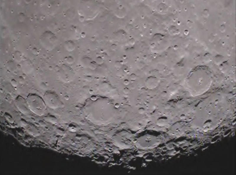
NASA Mission Returns First Video from Moon's Far Side


A camera aboard one of NASA's twin Gravity Recovery And Interior Laboratory (GRAIL) lunar spacecraft has returned its first unique view of the far side of the moon. MoonKAM, or Moon Knowledge Acquired by Middle school students, will be used by students nationwide to select lunar images for study.
GRAIL consists of two identical spacecraft, recently named Ebb and Flow, each of which is equipped with a MoonKAM. The images were taken as part of a test of Ebb's MoonKAM on Jan. 19. The GRAIL project plans to test the MoonKAM aboard Flow at a later date.
To view the 30-second video clip, visit: http://go.nasa.gov/zZXAPs .
In the video, the north pole of the moon is visible at the top of the screen as the spacecraft flies toward the lunar south pole. One of the first prominent geological features seen on the lower third of the moon is the Mare Orientale, a 560-mile-wide (900 kilometer) impact basin that straddles both the moon's near and far side.
The clip ends with rugged terrain just short of the lunar south pole. To the left of center, near the bottom of the screen, is the 93-mile-wide (149 kilometer) Drygalski crater with a distinctive star-shaped formation in the middle. The formation is a central peak, created many billions of years ago by a comet or asteroid impact.
The quality of the video is excellent and should energize our MoonKAM students as they prepare to explore the moon," said Maria Zuber, GRAIL principal investigator from the Massachusetts Institute of Technology in Cambridge.
The twin spacecraft successfully achieved lunar orbit this past New Year's Eve and New Year's Day. Previously named GRAIL-A and GRAIL-B, the washing machine-sized spacecraft received their new names from fourth graders at the Emily Dickinson Elementary School in Bozeman, Mont., following a nationwide student naming contest.
Thousands of fourth- to eighth-grade students will select target areas on the lunar surface and send requests to the GRAIL MoonKAM Mission Operations Center in San Diego. Photos of the target areas will be sent back by the satellites for students to study. The MoonKAM program is led by Sally Ride, America's first woman in space. Her team at Sally Ride Science and undergraduate students at the University of California in San Diego will engage middle schools across the country in the GRAIL mission and lunar exploration. GRAIL is NASA's first planetary mission carrying instruments fully dedicated to education and public outreach.
"We have had great response from schools around the country; more than 2,500 signed up to participate so far," Ride said. "In mid-March, the first pictures of the moon will be taken by students using MoonKAM. I expect this will excite many students about possible careers in science and engineering."
Launched in September 2011, Ebb and Flow periodically perform trajectory correction maneuvers that, over time, will lower their orbits to near-circular ones with an altitude of about 34 miles (55 kilometers). During their science mission, the duo will answer longstanding questions about the moon and give scientists a better understanding of how Earth and other rocky planets in the solar system formed.
NASA's Jet Propulsion Laboratory in Pasadena, Calif., manages the GRAIL mission for NASA's Science Mission Directorate in Washington. The GRAIL mission is part of the Discovery Program managed at NASA's Marshall Space Flight Center in Huntsville, Ala. Lockheed Martin Space Systems in Denver built the spacecraft.
For more information about GRAIL, visit: http://www.nasa.gov/grail .
Information about MoonKAM is available at: https://moonkam.ucsd.edu/ .